
📊 Full opportunity report: Radar That Never Blinks: What SAR Actually Does — for Companies, Institutions, and Governments on ThorstenMeyerAI.com — validation score, market gap, and execution plan.
TL;DR
Synthetic Aperture Radar (SAR) is a satellite imaging technology that operates independently of weather and light conditions. It is increasingly used by commercial, institutional, and government entities for monitoring, defense, and disaster response, with a rapidly growing market projected to reach $18.8 billion by 2034.
In 2026, commercial and government satellite operators are deploying extensive Synthetic Aperture Radar (SAR) constellations that provide all-weather, day-and-night imaging capabilities. This marks a significant shift from traditional optical satellites, offering persistent surveillance regardless of weather or sunlight, and transforming industries from defense to disaster management.
SAR satellites transmit microwave pulses toward the ground and record the reflected signals, enabling high-resolution imaging that is unaffected by clouds, fog, or darkness. Unlike optical imagery, SAR captures phase information, allowing for precise measurement of ground deformation through techniques like InSAR. This capability is vital for monitoring infrastructure stability, detecting ground shifts, and tracking vessels or vehicles even if they switch off transponders.
Commercial players such as ICEYE, Umbra, and Capella Space have expanded their constellations significantly, with ICEYE targeting over €1 billion in revenue in 2026 and securing major contracts like a €1.76 billion deal with the German Bundeswehr. European nations are increasingly deploying their own SAR satellites, signaling a move toward sovereignty and independent surveillance capabilities. The technology’s growth is driven by its utility across industries, including insurance, infrastructure, maritime, agriculture, and research, where timely, reliable data can influence decision-making and operational efficiency.
Radar That Never Blinks
What SAR Does — for Companies, Institutions, Governments
Active microwave imaging: its own illumination, any weather, any hour. The sensor is solved — the reading of it isn’t.
Three consequences of the physics
Active sensor: transmits its own microwave pulses. Same image quality at 3 a.m. in a North Sea storm as at noon in the Sahara.
Phase-coherent imaging enables InSAR: ground deformation at millimeter scale — subsiding dams, sagging bridges, hidden excavation.
Metal reflects radar strongly. A ship that switches off its transponder vanishes from tracking sites — not from a radar image.
Who buys it, and why — three different answers
- Insurance: flood-extent maps within hours, through the storm — parametric payouts before adjusters arrive
- Infrastructure & energy: InSAR subsidence alerts on pipelines, rail, dams — no ground sensors
- Maritime & commodities: dark-vessel detection, port congestion, storage monitoring
- Caveat: buy analytics, not raw phase histories — the value is in the interpretation layer
- Disaster response: damage proxies and flood maps while optical is blind
- Climate science: ice velocity, deforestation under perpetual cloud (Sentinel-1, free & open)
- OSINT & journalism: verifiable all-weather evidence — normalized by Ukraine, institutionalized since
- Caveat: radar literacy is scarce — misread speckle becomes a confident, wrong “convoy”
- Deterrence: continuous all-weather watch closes the cloud-cover exploit window
- Verification: arms-control and sanctions evidence that doesn’t blink
- Autonomy: a subscription can be throttled by a foreign provider; a nationally-tasked constellation can’t
- Caveat: collection has outrun exploitation — the analyst corps can’t screen sub-hourly revisit manually
Europe is buying constellations, not just imagery
THE EXPLOITATION GAP
The scarce resource is no longer the satellite — it’s the software that turns phase histories into detections and decisions, in the jurisdiction the mission requires. Whoever owns the software that reads the radar owns the value of the constellation above it. Buying satellites while importing the exploitation stack just moves the dependency one layer up.
How SAR Reshapes Surveillance and Industry
SAR’s ability to provide consistent, all-weather, day-and-night imaging is revolutionizing how governments, companies, and organizations monitor the environment and infrastructure. Its use in disaster response, security, and resource management enhances operational resilience and strategic autonomy. The expanding commercial market indicates that SAR is becoming a critical component of modern remote sensing, with implications for sovereignty, privacy, and global security.

InSAR Imaging of Aleutian Volcanoes: Monitoring a Volcanic Arc from Space (Springer Praxis Books)
As an affiliate, we earn on qualifying purchases.
As an affiliate, we earn on qualifying purchases.
Rapid Growth of Commercial and National SAR Constellations
Over the past decade, SAR technology transitioned from a predominantly military tool to a commercial commodity. Today, companies like ICEYE operate dozens of satellites with revisit times under an hour, serving clients across Europe and beyond. European nations are investing in their own SAR constellations, reflecting a strategic shift toward independent surveillance capabilities. The market is projected to grow from $7.45 billion in 2026 to nearly $19 billion by 2034, driven by applications in insurance, infrastructure monitoring, maritime security, and scientific research.
This proliferation of constellations signifies a new era where satellite-based radar imaging is no longer an exotic military asset but a widespread resource for civilian and commercial use, with governments asserting sovereignty through their own satellite networks.
“Our constellation provides sub-hourly revisit times, enabling real-time monitoring of critical infrastructure and rapid disaster response.”
— ICEYE spokesperson
all-weather satellite imaging system
As an affiliate, we earn on qualifying purchases.
As an affiliate, we earn on qualifying purchases.
Unresolved Questions About SAR Data and Privacy
While the technical capabilities of SAR are well-established, questions remain about data privacy, regulation, and the potential for misuse. The extent to which commercial SAR data will be regulated, and how privacy concerns will be addressed as constellations grow, is still unclear. Additionally, the long-term sustainability and cost-effectiveness of large-scale SAR constellations are under discussion, with some experts questioning the future scalability of current models.
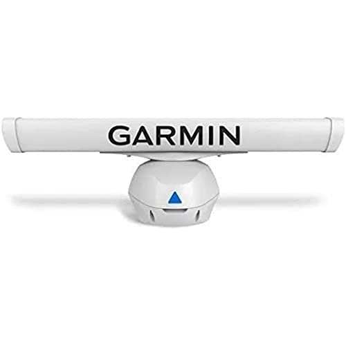
Garmin GMR Fantom 54-4 Open Array Radar
- Target Detection: Clear close and long-range detection
- Target Tracking: Color-coded moving target display
- Power Output: 50 watts of radar power
As an affiliate, we earn on qualifying purchases.
As an affiliate, we earn on qualifying purchases.
Upcoming Developments in SAR Satellite Deployments
Expect further launches of SAR satellites from both commercial and government entities, with increased focus on high revisit rates and enhanced resolution. Governments may formalize policies around data sharing and privacy, while industries continue integrating SAR analytics into their decision-making processes. The market’s rapid growth suggests that SAR will become a standard component of remote sensing infrastructure, influencing global security, environmental monitoring, and commercial operations.

Escort MAX 360c MKII Laser Radar Detector & Escort Direct Wire Power Cord: Dual-Band Wi-Fi and Bluetooth, 360° Directional Arrows, Exceptional Range, Shared Alerts, Drive Smarter App, Black
- Enhanced Detection Range: 50% better than previous model
- Fast Threat Detection: Processes signals instantly from all directions
- Directional Arrows: Shows threat direction clearly
As an affiliate, we earn on qualifying purchases.
As an affiliate, we earn on qualifying purchases.
Key Questions
How does SAR technology differ from optical satellite imaging?
SAR uses microwave pulses to generate images regardless of weather or lighting, while optical satellites rely on sunlight and clear skies for imaging, making SAR more reliable in adverse conditions.
Who are the main commercial players in SAR satellite deployment?
Leading companies include ICEYE, Umbra, Capella Space, and Japan’s Synspective, each operating extensive constellations with high revisit capabilities.
What are the primary applications of SAR data for industries?
Key uses include disaster response, infrastructure monitoring, maritime security, agriculture, and resource management, where consistent, timely data is critical.
Are there privacy concerns related to SAR satellite imaging?
Yes, as SAR can detect ground movements and identify structures without permission, privacy and regulation issues are emerging, though specifics are still being developed.
Will SAR replace optical imagery entirely?
No, SAR complements optical data by providing persistent coverage in conditions where optical imaging fails. Both technologies are likely to be used together for comprehensive monitoring.
Source: ThorstenMeyerAI.com